OTTO-1 High Altitude Balloon Launch from ICSTARS Ranch
NEWS FLASH: January 6th, 2011
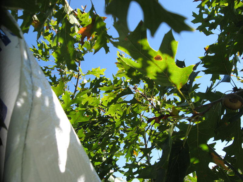
The balloon payload has been found, 30 feet up in a tree near Calhoun, MO!
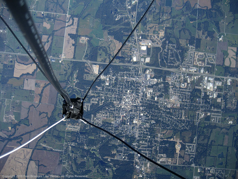
Warrensburg, Missouri from 28,000 feet.
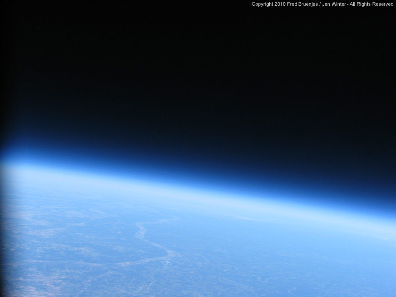
The view from 100,000 feet! The last image taken just seconds before the balloon burst.
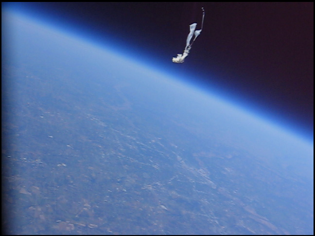
Shards of the balloon fall away after it burst.
The tree where it landed, 30 feet in the air, and where it was caught for three months until some kind folks cut it out of the tree and notified us. Thanks guys!
Post mortem on the payload shows that the antenna connector broke off at about 70,000 feet altitude. We have the moment it broke on video. Otherwise the payload was completely intact!
The OTTO-1 Launch, October 5, 2010:
Our associate Sean wanted to launch a high altitude balloon to the edge of space, inspired by a group of students. With his financial support, he ordered and we assembled a balloon payload package that successfully launched to over 100,000 feet.
The package consisted of:
- 1500g sounding balloon.
- Helium, bought at Airgas. The tank of Helium was the single biggest expense ($400) and over half of the total expeditures.
- 5 foot parachute, made of house-wrap Tyvek from the local Lowe's.
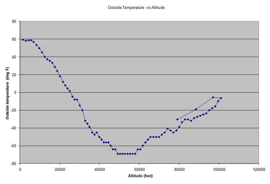
- Foam box, using some left over packing materials. We used two Hot Hands hand warmers to keep the electronics happy. Telemetry showed outside temperatures down to -69 °F (-56 °C) while it stayed 70 °F inside the box.
- Tadiran Lithium batteries, left over from a seven year old project. (Fred had purchased them for use at Antarctica's 2003 total solar eclipse).
- Argent Data Systems' OpenTracker+ APRS tracker.
- Garmin GPS 18-LVC puck receiver, which is known to work above 60,000 feet.
- Radiometrix' HX1-144.390-3 300mW transmitter.
- 1/4 wave ground plane transmitting antenna, made of 12 ga. romex and some leftover RG-8 from a radio astronomy project to monitor Jupiter's lightning.
- An external temperature sensor consisting of a 2252 ohm thermistor to ground with 4.7k resistor pullup to 5V.
- Canon SD630 camera, modified to use CHDK firmware.
- Canon A560 camera, modified to use CHDK firmware with mode dial support so that it could switch between stills and movies.
The cameras were scripted to take exposures and movies at periodic intervals, based on EOSS's A570IS script. Our A560 script switched between a taking a high resolution still and 30 seconds of video. The SD630 script took stills at varying intervals.
To keep life simple, we kept the balloon FAR 101 exempt. Working feverishly with only 3-4 hours of sleep a night, we finished the package in time for a launch on Tuesday October 5th, when the weather was forecast to be perfect, with clear skies, nice temperatures, and near zero winds anywhere in the atmosphere. Near Space Ventures' trajectory forecast was very useful in predicting where the balloon would go. We really didn't want to overfly the nearby Whiteman Air Force Base, home of the B2 Spirit stealth bombers...
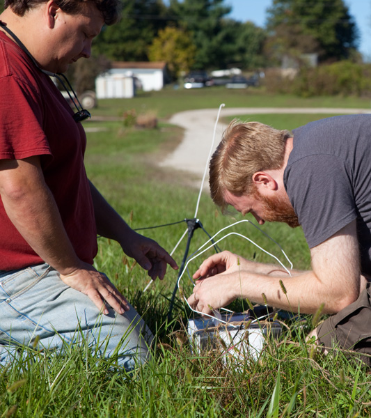
Fred (KG6YRB) turns on and loads the electronics. Coat hangers were installed to prevent it from landing GPS side down.
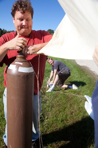
Sean fills the balloon.
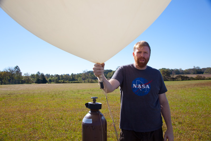
Insert funny caption.
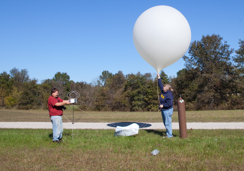
Jen releases the balloon. This first attempt failed to lift off, we had not filled the balloon enough.
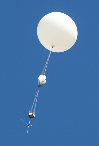
Up, up, and away! Notice the fouled parachute lines.
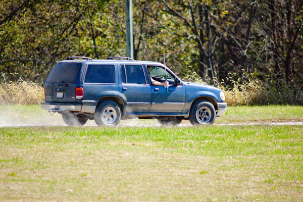
The chase team speeds away to track the balloon with a yagi antenna made of 12 ga. romex.
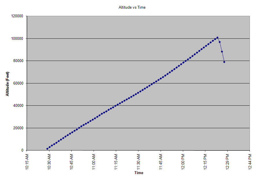
Monitoring the telemetry received direct from the balloon, we were soon overjoyed to see that we had reached over 100,000 feet!
2010-10-05 12:20:01 12:20:01R KG6YRB-11>APOTC1,WIDE1-1,WIDE2-1 Port=1 : >OTTO-1 ICSTARS high altitude balloon
2010-10-05 12:20:02 12:20:02R KG6YRB-11>APOTC1,WIDE1-1,WIDE2-1 Port=1 : /172006h3834.61N/09340.15WO158/013/A=098027 09.7V 21C HDOP01.0 SATS11
2010-10-05 12:20:02 12:20:02R KG6YRB-11>APOTC1,WIDE1-1,WIDE2-1 Port=1 : T#090,150,135,225,228,156,00000010
2010-10-05 12:21:33 12:21:33R KG6YRB-11>APOTC1,WIDE1-1,WIDE2-1 Port=1 : /172138h3834.38N/09339.93WO113/018/A=099499 09.8V 21C HDOP00.9 SATS11
2010-10-05 12:21:34 12:21:34R KG6YRB-11>APOTC1,WIDE1-1,WIDE2-1 Port=1 : T#091,150,136,219,236,166,00000010
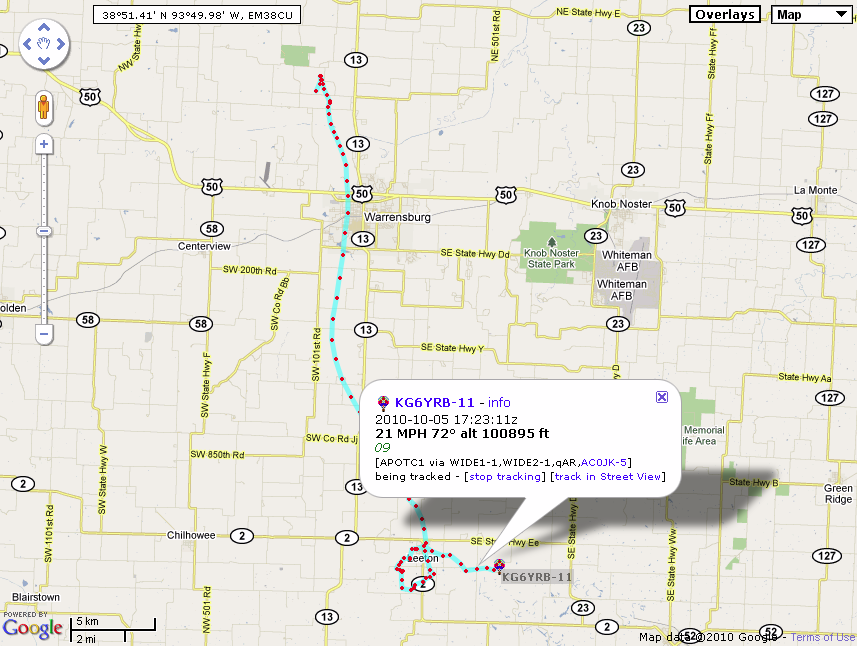
2010-10-05 12:23:05 12:23:05R KG6YRB-11>APOTC1,WIDE1-1,WIDE2-1 Port=1 : /172310h3834.43N/09339.49WO072/018/A=100895 09.7V 21C HDOP01.0 SATS11
2010-10-05 12:23:05 12:23:05R KG6YRB-11>APOTC1,WIDE1-1,WIDE2-1 Port=1 : T#092,150,135,215,224,147,00000010
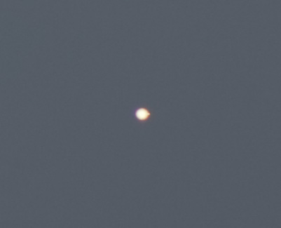
Jen used a 600mm lens to take this image just seconds before burst, showing the balloon above 100,000 feet! It has expanded to about 30 feet across.
We could still see the balloon with the naked eye all the way until it burst. The sky was so clear, and with the balloon backlit by the sun it was an easy object to see. Fred and Jen saw the balloon burst, in which the balloon just faded away into nothingness over about one second.
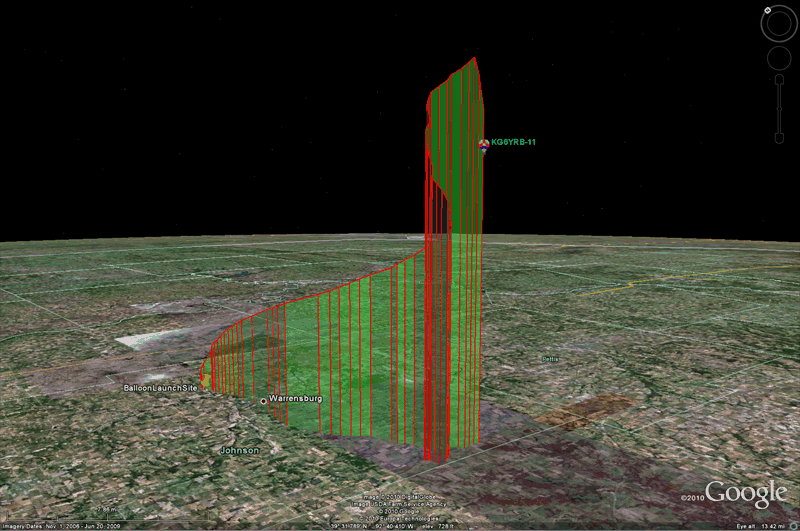
Click on image for the live tracking map.
After the position report at 79,014 feet, we never heard from the payload package again. We surmise that the parachute lines were fouled, which caused it to tumble and eventually separate from the parachute and antenna. Sean spotted a flat white object drifting down that could have been the parachute by itself. Extensive ground searches for the payload box have so far not been successful. It could have lithobraked anywhere from Leeton to Windsor to Clinton, an impossibly large search area.
Click on image for a Google Earth kmz file of the flight path.
The decoded telemetry can be downloaded as an Excel spreadsheet here.
Lessons Learned
- Improve harness to help prevent parachute lines from getting tangled. Have launch personnel practice preventing and watching for tangles.
- Make the GPS - transmitter - battery connections as robust as possible. Make a PCB instead of using dead bug assembly techniques. Toss it down some stairs to test robustness.
- Use an ATV downlink to get live pictures back. Would be much more fun and in case the payload is lost, then you have SOME pictures.
- Powering the cameras is a pain, Fred ended up using the stock internal battery for the SD630 and soldering 8 AA batteries in parallel for the A560. Next time, a 3.15v voltage regulator should be used so that the cameras can be powered off the lithium battery pack.
- Use APRS path of WIDE2-1 not WIDE1-1,WIDE2-1 to reduce congestion.
- A redundant tracking transmitter would be nice... a higher rate of transmission, not transmitting on 144.39, would allow finer position resolution.
Would we do it again? Heck yeah, but only with a better budget so that the improvements mentioned above could be implemented.